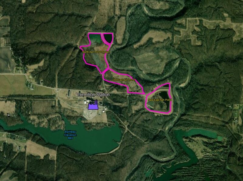
At Prairie Rivers Network, we are thrilled to introduce our new Coal Ash Map, a tool designed to provide comprehensive information about coal ash impoundments at major power plants across Illinois. This interactive map is a one-stop-shop for anyone seeking answers about coal ash disposal and its impact on our environment and communities across Illinois.
Coal Ash Map
You can also see a full screen map here.
What is Coal Ash?
Coal ash is the toxic residue left behind when coal is burned for electricity. It contains harmful heavy metals such as mercury, arsenic, selenium, chromium, and cadmium, which can cause serious health problems in humans, including cancer and brain damage, and can also devastate local fish and wildlife populations. Unfortunately, the disposal of coal ash was under-regulated for decades, leading to widespread environmental contamination. The roll out of state and federal coal as regulations has provided us with insight and information that is collected in this map.
The Problem: Coal Ash Leaking into Our Waters
Illinois has the dubious distinction of leading the nation in coal ash damage cases. A 2018 report by Prairie Rivers Network revealed that groundwater at 22 of 24 reporting coal ash dump sites in Illinois contained unsafe levels of toxic pollutants. One of the most alarming cases is along the Middle Fork of the Vermilion River, Illinois’ only National Scenic River, which is threatened by 3.3 million cubic yards of coal ash from Dynegy/Vistra’s coal ash pits.
The Solution: Better Laws and Community Action
To combat this environmental crisis, Prairie Rivers Network is advocating for stronger regulations and enforcement to protect our land and water. We successfully worked with partners to pass the 2019 Coal Ash Pollution Prevention Act, and have been working to ensure that law and the rules for cleaning up coal ash that it created are enforced and living up to the spirit of the law. .
Key Actions for a Safer Future
Our strategy includes several key actions:
- Ensuring fossil fuel infrastructure owners properly clean up their waste.
- Strengthening regulation and enforcement of discharges from fossil fuel infrastructure.
- Deterring investment in new fossil fuel infrastructure.
- Supporting environmentally sound renewable energy programs, including recycling and responsible sourcing.
- Advocating for reforms to federal biofuels policies to promote sustainable agricultural practices.
Exploring the Coal Ash Map
The Coal Ash Map is an invaluable resource for anyone concerned about the impact of coal ash on our environment. By clicking on any power plant, users can access detailed information about specific coal ash impoundments, including the company that is operating or operated the site, site documentation created by the company to comply with federal and state laws, documents from the Illinois EPA and closure permits.
Additionally, the map provides documentation such as water discharge (NPDES) permits, impoundment dam stability reports and more, offering a comprehensive view of each site.
Layers of Information
The map features three distinct layers:
- Coal Plants: The top layer includes all coal plants, both operational and closed. You can zoom in to find detailed information about the impoundments at each plant.
- Impoundment Details: This layer provides specific information about each impoundment, including compliance pages and data related to their environmental impact.
- Ground Monitoring Wells: This layer shows the locations of ground monitoring wells that track pollution levels from coal ash runoff, providing critical data on groundwater safety.
A Resource for All
This map is designed to be a valuable resource for residents, activists, politicians, reporters, river users, and anyone else seeking to understand the impact of coal ash in their area. Whether you’re looking for compliance information, groundwater monitoring data, or details on specific impoundments, the Coal Ash Map brings together all the necessary information in one accessible platform. We’re going to keep it updated with documents and other resources as they become available.
Get Involved
We invite you to explore the Coal Ash Map and join us in our fight for cleaner, safer water in Illinois. By staying informed and taking action, you can help ensure that our state’s communities and natural resources are protected from the dangers of coal ash pollution.
Feel free to share your feedback and suggestions to help us improve this valuable tool.


