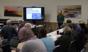
On December 18th, PRN and the IDEA Farm Network hosted speaker Dr. Nicholas Jordan from the University of Minnesota to discuss collaborative geodesign and agricultural land use.

Collaborative GeoDesign is a mapping tool that lets people look at a farming economy and make planning decisions based on different variables. Collaborative geodesign helps the many voices in agriculture (including farmers, Soil and Water Conservation Districts (SWCDs), environmental organizations, and others) workout how best to improve land use while protecting our soil and water. While Dr. Jordan’s work looks specifically at Minnesota and Iowa watersheds, the hope is to expand these to other areas.
How does it work?
The GIS based program incorporates modeling of a watershed’s soil, topography and waterways, and the users select the type of farming techniques that could be used in an area. For example, areas of conservation tillage, cover crops, grassed waterways, stream buffers, or prairie grass can be drawn, and the program calculates the nitrate, sediment, phosphorus, water yield, habitat quality, and market return that would result from those changes to the landscape in the watershed.
“Collaborative geodesign is a process that allows groups of diverse stakeholders to “try-on” various landscape designs assisted by a geodesign tool,” the site said.
Ultimately, this tool used in a collaborative process shows how using different farming techniques can have an impact on water quality in the local watershed while also balancing farmers’ bottomline.

SWCDs in Illinois could benefit from access to this program, once data from their watershed areas are mapped. Steve Fulling of the Crawford County SWCD thought that it was proactive to use GeoDesign as a way of finding solutions for rural communities, and Bill Davison of University of Illinois Extension said, “there’s a great need for it, and the hope is finding a way to use it to benefit rural farmers.”
“We need watershed scale examples,” Dr. Jordan said. “We need to show that folks are making money,” for this to be useful.
Planning conservation at a watershed level allows us to achieve measurable water quality results. Thinking at the watershed level versus the farm level also presents opportunities for targeting areas in the watershed where conservation practices will get their best bang for their buck, thus achieving more with our limited funds.


