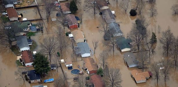
Poor river policies wreak havoc on river towns and fragile ecosystems
by Kim Knowles
Governor Bruce Rauner has declared 23 Illinois counties disaster areas due to flood damages. Widespread flooding has shut down businesses, closed roads, forced evacuations, and taken lives as intense winter precipitation caused the Missouri and Mississippi Rivers to flood towns in Missouri, Illinois, and other Mississippi River states. While winter flooding of this intensity is unusual, it is not surprising to experts studying trends in the Midwest.
Recent studies have shown that the frequency of flooding in the Midwest has increased and is expected to further intensify (PDF) by mid-century. This is in part due to climate change and the predicted long-term changes in Midwestern weather patterns that show an increase in frequency and intensity of extreme precipitation. More storms are expected, and when they come, they are expected to dump more rain.

But the intensification of flooding is also due, in large part, to bad river management. First, according to Robert Criss, PhD of Washington University, who has studied major rivers for decades, both the Federal Emergency Management Agency (FEMA) and the Army Corps of Engineers (the Corps) are underestimating the risk of flooding by using outdated methods for assessing risk, and outdated flood maps. These agencies may be underestimating flood levels by as much as five feet. An increase in flood levels of this magnitude could cause catastrophic failure of flood protection systems.
Second, much of the Mississippi River and its major tributaries are walled off from their natural floodplains. For instance, between Le Claire, Iowa and Alton, Illinois, 50% (nearly 300 river miles) of the Mississippi’s floodplain is behind federal levees. In the lower Illinois, at least 60% (160 miles) of the river’s floodplain is leveed. With so many levees, we’ve lost the myriad benefits provided by floodplains, including an immense capacity for absorbing flood waters, natural filtration of pollutants, aquifer recharge, and biologically rich habitat for fish, migrating birds, and countless other wild species. Although levees can provide local flood protection, the water has to go somewhere, and we’re often just pushing the problem downstream.
Third, in addition to cutting off rivers from floodplains, the Army Corps of Engineers has loaded the Mississippi River with thousands of river training structures, things like weirs, dikes, and chevrons that constrict the river so that it flows in a deeper and straighter channel for navigation purposes. This helps save money on dredging, but comes at a huge cost to both people and wildlife.
There is ample evidence that river training structures increase flood heights by as much as 10 to 15 feet in the Middle Mississippi River*, and that they have destroyed fish and wildlife habitat. According to the US Geological Survey, the Corps’ management of the Upper Mississippi River is destroying critical river habitat, including backwaters, side channels, and wetlands. These losses have been particularly hard on endangered and threatened species like the least tern, the pallid sturgeon, and the Indiana bat.
We need smarter river policies. With more extreme storm events coming, it’s clear we can’t simply engineer our way out of this mess. Will the latest catastrophes in the Midwest help us change? Let’s hope so-and work to ensure they will. More levees is not the answer. If we are to protect communities and restore the habitat we’ve lost, we need to let floodplains be floodplains. To that end, Prairie Rivers Network will be working with trusted partners on projects that reconnect rivers with their floodplains. Stay tuned.
*Pinter, N., A.A. Jemberie, J.W.F. Remo, R.A. Heine, and B.A. Ickes, 2010. Empirical modeling of hydrologic response to river engineering, Mississippi and Lower Missouri Rivers. River Research and Applications, 26: 546-571; Remo, J.W.F., N. Pinter, and R.A. Heine, 2009. The use of retro- and scenario- modeling to assess effects of 100+ years river engineering and land cover change on Middle and Lower Mississippi River flood stages. Journal of Hydrology, 376: 403-416.


