Day after day, we are seeing stories about federal rollbacks and funding cuts for environmental protections. In the same breath, we are experiencing more and more catastrophic storms and flash flooding wreaking havoc on our communities throughout not just Illinois but the nation. In this Sunday Scoop, we are diving into a decades-long localized conservation effort that’s making waves in the Quad Cities – the fight to protect the Milan Bottoms.
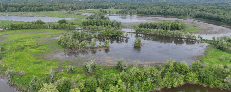
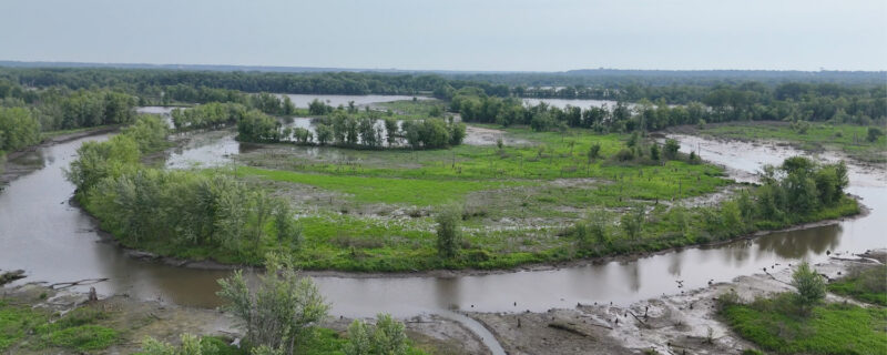
Nestled quietly between Interstate 280 and the small town of Andalusia, Illinois lies one of the Quad Cities’ best-kept secrets — a sprawling 3,500-acre wetland complex known as the Milan Bottoms. This remarkable ecosystem represents something increasingly rare in our developed landscape: a largely intact natural habitat that has somehow survived the steady march of development impacting the Illinois landscape. For decades, dedicated conservationists, local community members, and wildlife enthusiasts have advocated for the protection of these precious wetlands.
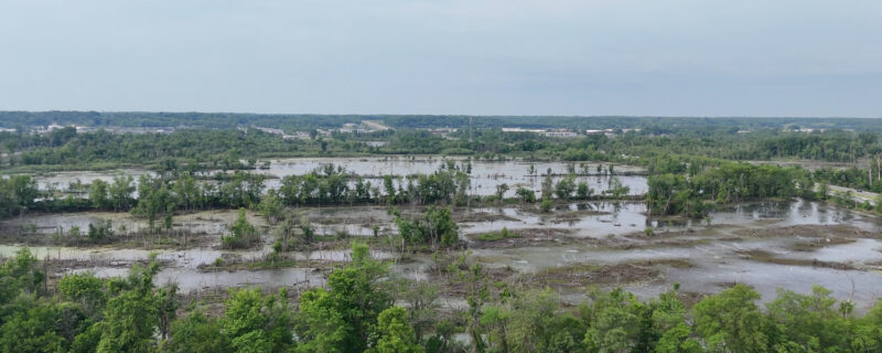
The Milan Bottoms isn’t just a pretty patch of wetland – it’s a biological powerhouse that quietly performs essential services for the Quad Cities every single day. During spring floods, these wetlands act like a massive sponge, storing billions of gallons of water that would otherwise inundate neighboring homes, businesses, and countless communities downstream. As water moves through the wetland, sediment settles and plants filter out pollutants, sending cleaner water back into the Mississippi River.
The numbers tell an impressive story: a 2005 survey documented over 150 species calling this wetland home, including 10 that are federally or state-protected. The rare Blanding’s turtle navigates the shallow waters below while Indiana bats take flight at dusk. Black-crowned night herons wade through the reeds alongside dozens of other bird species that rely on this habitat during their epic migrations. Milan Bottoms also houses one of the Midwest’s largest documented Bald Eagle night roosts – making it a critical ecosystem for these birds.
Development Sparks Action

In spring 2023, the City of Rock Island acquired over 500 acres of these critical wetlands near where the Rock River meets the Mississippi. Within this area sits a 10-acre parcel of land, once used by RiverStone Group Inc as sand and gravel quarries.
A proposal to develop a truck stop and cannabis dispensary on this parcel has emerged, raising concerns among residents, wildlife advocates, Prairie Rivers Network, and many of our partners about the long-term health and vitality of the Milan Bottoms ecosystem. While a majority of the wetland sits in the Mississippi River floodway, according to very dated maps from FEMA, the parcel does not. But the site’s proximity to this vital wetland has sparked widespread concern about the long-term ecological impacts of this development – and the community is speaking up.
Sierra Club, Prairie Rivers Network, and a coalition of residents and environmentalists who have long advocated for the area submitted a letter of concern to the City of Rock Island in February 2025 – highlighting the importance of protecting this natural treasure and asking for transparency on the development’s future. Included in this group was Nina Struss, PRN’s River Health and Resiliency Organizer, who calls the Quad Cities home. Following this letter, city officials invited members of the coalition to an informational meeting, allowing space for public input.
During this meeting, the idea for wetland protection became a reality. In alignment with fellow environmental advocates, Nina urged the city to formalize its statements against future development by establishing a conservation easement.
A Science-Backed Solution
This isn’t wishful thinking — it’s a community-centered and data-driven approach to building climate resilience. The protection of Milan Bottoms aligns directly with recommendations from a comprehensive Quad Cities climate assessment conducted by Prairie Rivers Network, the National Wildlife Federation, and the University of Illinois’ Discovery Partners Institute. As climate change increases flood risks along the Mississippi River, preserving natural flood control systems becomes not just environmentally wise for our survival but economically essential.
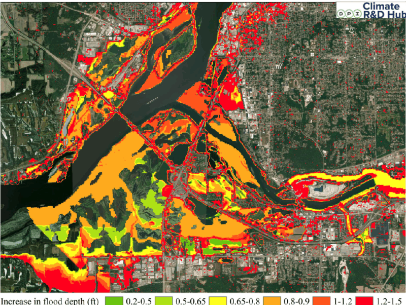
The map above shows a hypothetical situation where the Milan Bottoms wetlands are completely developed. Development would not only be extremely costly because of its location in the floodplain, it would also increase the amount of impervious surfaces, reducing the amount of floodwater that can be absorbed into the ground. Data in this hypothetical scenario shows that developing the Milan Bottoms wetlands could increase regional flooding by up to 18 inches.
These wetlands work much like the nearby Nahant Marsh, which stores and filters up to 2 billion gallons of water during peak flooding in its impressive 328 acre preserve. In an era of increasingly extreme weather, this natural infrastructure is invaluable not only to local community members and regional wildlife, but to downstream communities as well.
Lets not forget about the 10-acre parcel of land that is “prime” for development within the wetlands. While this parcel is “technically” out of the floodplain, it doesn’t mean it isn’t at risk for potential future flooding. Both Illinois and Iowa are already experiencing the effects of climate change, including more frequent heat waves and changing precipitation patterns. These changes in precipitation patterns can lead to more intense rainfall events, increasing flood risk, especially for flash flooding. Data from our assessment’s Interactive Flood Map shows the 10 acre parcel to be susceptible to flooding of depths up to 6-8 feet in a flood event.
Protecting What Matters

To finance the proposed development of the parcel, the city conducted a feasibility study for expanding a Tax Increment Financing (TIF) District, which includes the wetland area. TIFs work by using the extra property tax money that comes in when property values go up due to new development. That extra money is then reinvested into the area to support more growth.
Concurrently, a Business Redevelopment District (BRD) Plan was introduced for council approval. A BRD is a designated geographic area where cities can use targeted incentives, tax increment financing, and streamlined development processes to encourage private investment and revitalize underperforming commercial or industrial properties. The goal is to turn these underused properties into thriving businesses, bring in more tax revenue, create jobs, and boost the local economy – without needing a big upfront investment from taxpayers.
Several processes must happen prior to the TIF and BRD approval, one of which is the requirement for public comment. PRN along with concerned community members and environmentalists showed up in numbers at both the March 10th city council meeting and the public hearings for the TIF and BRD on March 17th to protest the financing of the proposed development that will harm the biodiversity and structural integrity of the Milan Bottoms.
On March 24th, Rock Island City Council passed the Business Redevelopment District Plan, allowing for future development incentives to occur within the same area as the Milan Bottoms. At this meeting, PRN and NWF fought for additional text that recognizes the vital role wetlands play – from supporting the local economy to helping the city better withstand current and future climate risks.
On July 14, 2025, the Rock Island City Council passed the ordinance to expand the Parkway/I-280 TIF district, primarily to support the proposed development on the parcel, known as the Casino West Site. While the TIF remains highly controversial within the community as it pertains to this development, there are slight benefits within the scope of wetland protection. The city has affirmed that TIF funds could also be utilized for wetland protection — creating an intriguing possibility where development revenue could help fund conservation efforts.
A Vision Takes Shape
In response to the public outcry for protection of the Milan Bottoms, the Rock Island Mayor and City Council stepped up to the challenge, announcing their plan to protect roughly 600 acres of wetlands in perpetuity through a conservation easement. It was more than just a policy decision — it was a statement about the kind of community Rock Island wants to be both now and in the future.
The announcement (PDF) came with a directive for comprehensive planning. A mayor-appointed task force, including representatives from Prairie Rivers Network, city staff, council members, landowners, and conservation experts, was charged with creating a wetland management plan involving robust stakeholder engagement within twelve months. The official resolution reads as follows:
“Now, therefore, be it resolved that the City Council directs the City Manager, in consultation with a Mayor-appointed task force, to create within twelve months a wetland management plan involving a robust stakeholder engagement process. The plan shall include a proposed governance framework establishing how the wetlands shall be managed and by whom. It shall also include recommendations for future investments that both preserve the natural environment and further the public interest. Be it further resolved that the City Council directs the City Manager within six months to present a recommendation on the establishment of a conservation easement that would be presented to the Rock Island City Council prohibiting future commercial development in the wetland area.”
Since their first meeting in April 2025, the task force has worked diligently, consulting with land trusts, the Illinois Department of Natural Resources, and the Illinois Nature Preserves Commission to explore the best options for long-term protection.
These efforts culminated on June 23, when Nina presented potential options to protect the wetlands to the Rock Island City Council on behalf of the task force. While options for a conservation easement through a land trust and protection through the Illinois Nature Preserves Commission (INPC) were both discussed, the task force ultimately recommended designating the 600 acres of wetlands as a Land and Water Reserve with the INPC – a move that would offer strong, lasting protection for this critical habitat forever.
The Moment of Truth
Thanks to the decades-long advocacy efforts from the conservation community, Friends of the Milan Bottoms, and community members across the area we are at a critical decision point. As conversations continue around nearby land use and long-term planning, one thing is clear: there’s broad agreement on the need to protect the Milan Bottoms wetlands for the health and resilience of our communities.
Tomorrow, July 28, the Rock Island City Council will vote on the Land and Water Reserve Commitment Resolution – a key step toward permanent protection through the Illinois Nature Preserves Commission. If passed, it will set the city on a path toward official designation by 2027, safeguarding over 600 acres of wetlands that filter water, absorb floods, and shelter hundreds of species.
This vote is about more than land – it’s about values. It’s a chance for Rock Island to show that protecting nature and growing the economy go hand-in-hand. Like past leaders who invested in riverfronts and revitalized downtown, today’s decision-makers have the opportunity to leave a legacy future generations will thank them for.
Federal rollbacks of bedrock clean water protections require city and state leaders to step up to advance protections. Prairie Rivers Network strongly urges the City to seize this moment.
The Milan Bottoms have quietly served our community for decades. Now, we have the opportunity to return the favor. The choice is clear.
Let’s protect what protects us.
Prairie Rivers Network launched our Clean Water Forever campaign to change the way Illinois thinks and cares for its water. Our work in the Quad Cities is just one example of our commitment. To support this work directly and so much more, please donate today.