Contents
- 1. Overview
- 2. What is Coal Ash?
- 3. What are the Ash Pits?
- 4. Middle Fork River; What is at Risk?
- 5. What is Dynegy’s Plan for the Pits?
- 6. Timeline; History of the Site
- 7. Vermilion County Passes Resolution
- 8. US EPA Coal Ash Rules and Vermilion
Overview
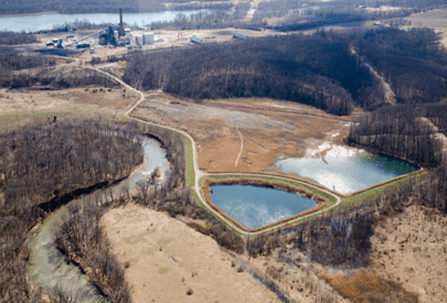
Community members have long been concerned about the coal ash stored at the Dynegy Vermilion Power Plant in Oakwood, Illinois. The coal-fired power plant operated from 1955 through December 2011, dumping coal ash (a toxic by-product from burning coal) in three ash pits — all located in the western floodplain of the Middle Fork of the Vermilion River, Illinois’ only National Scenic River.
The site presents three major issues: (1) ongoing pollution of groundwater that runs beneath the pits, and at points running through the pits; (2) pollution of the Middle Fork through seeps and hydrologically connected waters; and (3) the risk of a catastrophic breach, where massive amounts of coal ash could inundate the Middle Fork.
The two oldest ash pits (constructed in the mid-1950′s and 1970′s, respectively) were built without liners to protect underlying groundwater. Adding additional risk, the pits are now breaking down as a result of flooding and erosion from the river. Leakage of coal ash pollutants (including boron, sulfates, iron, and manganese) has already been noted in the groundwater, while discolored seeps can be readily seen from the river.
The third newest pit (constructed in the 1980′s) presents problems of its own. Polluted wastewater discharges from the ash pit into the river have been permitted for decades, but critically important monitoring from common coal ash pollutants of concern was never required. Like the two older ash pits, the third pit has been worn by the force of the river, presenting a risk to its stability. This risk is compounded by the location of the pit over old coal mine voids — presenting the potential for subsidence (sinking of the land).
Dynegy has proposed to simply cap these pits and walk away from the liabilities. This proposal would leave the coal ash in place at the dump site, with only a cap over the pits to prevent additional water from getting in. This plan would allow groundwater contamination and seepage to the river to continue in perpetuity, while failing to address the threat of a catastrophic breach.

Bald Eagles reside on the Middle Fork of the Vermilion River
Leaving coal ash in the floodplain, vulnerable to the force of the river, with the proposed “cap closure option” for the impoundments isnot sufficient to protect local residents, businesses, and Illinois taxpayers from the burden of ongoing pollution and a potential breach.
In order to support the integrity of the vibrant Middle Fork river system and the communities that rely on it, complete removal of this dangerous waste from the floodplain is necessary.
Moreover, complete removal and responsible closure would allow for the long-term conversion of this land away from a waste dump, completing the 17-mile river coordinator and connecting protected recreational lands for the benefit of Illinois’ citizens and wildlife.
What is Coal Ash?
Coal ash is the solid by-product that is left over after coal is burned for electricity — much like ash is left over after burning wood in a fire.
Coal ash, also referred to as “Coal Combustion Residuals” (or CCRs), broadly refers to several by-products:
- Fly Ash: a very fine, powdery material composed mostly of silica made from the burning of finely ground coal in a boiler
- Bottom Ash: a coarse, angular ash particle that is too large to be carried up into the smoke stacks, so it forms in the bottom of the coal furnace
- Boiler Slag: molten bottom ash
- Flue Gas Desulfurization Material: leftover from the process of reducing sulfur dioxide emissions from a coal-fired boiler that can be a wet sludge consisting of calcium sulfite or calcium sulfate or a dry powdered material that is a mixture of sulfites and sulfates
When coal is mined, it already contains carbon alongside a number of heavy metals and minerals — including mercury, arsenic, selenium, chromium, and cadmium, which can cause cancer and brain damage in humans and are harmful to fish and wildlife.
When coal is burned, much of the carbon burns off (combining with oxygen to produce Carbon Dioxide, or CO2). What’s left (coal ash) has these same metals that were there all along, but now at 10-100x higher concentrations.
What are the Ash Pits?
There are three ash pits at the Dynegy Vermilion facility: (1) the Old East Ash Pond; (2) the North Ash Pond System; and (3) the New East Ash Pond System. Also called “ash ponds” or “ash impoundments,” these are disposal sites formed by perimeter earthen embankments.
These pits contain a mix of coal ash materials (including fly ash, bottom ash, boiler slag, and other materials) with different chemical compositions (because of different types of coal burned over the power plant’s lifetime).
(1) The Old East Ash Pond was put into service in the mid-1950′s and operated until the mid-1970′s.
- Unlined
- In the Middle Fork floodplain (subject to erosion)
- Total Volume: 1,183,413 cubic yards
(2) The North Ash Pond System (one large pit for disposal, another smaller pit for sedimentation of overflow) was utilized from the mid-1970′s to 1989.
- Unlined
- In the Middle Fork floodplain (subject to erosion)
- Total Volume: 1,618,335 cubic yards
(3) The New East Ash Pond System (one large pit for disposal, another smaller pit for sedimentation of overflow) was utilized from 1989 until the plants closure.
- Clay liner
- In the Middle Fork floodplain (subject to erosion)
- Located over mine void (subject to subsidence: sinking of the land)
- Total Volume: 534,013 cubic yards
The total volume of the pits is 3,335,761 cubic yards. For some context, the total volume could fill New York City’s Empire State Building 2.4 times, or over 1000 Olympic swimming pools.

Dynegy’s own reports state that the pits are now contaminating the groundwater and that groundwater is flowing toward the Middle Fork. There are already visible seeps along the bank, and detectable impacts in the water and aquatic life. This means that heavy metals in coal ash are currently placing the Middle Fork and adjacent groundwater at risk.
As the Middle Fork of the Vermilion River continues to wear away at the sides of these pits, the threat of a catastrophic breach continues to increase.
Middle Fork River: What is at Risk?

River otters swimming in the Middle Fork
The Middle Fork of the Vermilion River is a unique and cherished resource. The river been was the first state-designated State Scenic River, and is the only nationally-designated Scenic River in the state of Illinois.
In legislation, the Illinois General Assembly stated that it “recognizes the outstanding natural, scenic, recreational, ecological, historical and archaeological values of the middle fork of the Vermilion River in Vermilion County, Illinois, and deems the middle fork of the Vermilion River to be a natural resource of Statewide significance such that its natural and recreational values should be permanently preserved for the enjoyment of the people of the State of Illinois.”
The Middle Fork River Valley is home to 24 State threatened or endangered species, and supports a diverse and healthy population of 57 types of fish, 45 kinds of mammals, and 190 different birds.
The river system also provides the benefits of a strong recreation economy to Vermilion County. Kickapoo State Recreation Area, Kennekuk Cove County Park, and the Middle Fork State Fish and Wildlife Area stand as key destinations for local residents and visitors , enjoyed for canoeing, kayaking, wildlife viewing, photography, hunting, angling, hiking, and horseback riding.
According to a publication of the University of Illinois Springfield, in 2009 Kickapoo State Recreation Area, alone, hosted 1,458,491 visitors. Kickapoo Landing alone puts over 10,000 people on the Middle Fork River in canoes, kayaks and tubes each year.
It is clear that the unstable and polluting Dynegy ash pits are putting this unique resource at risk. As the state of Illinois recognized in its Corridor Management Plan, it must “work toward abatement of activities within the river area which are degrading water quality.”
What is Dynegy’s Plan for the Pits?
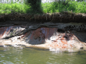
Visible seeps and torn lining along the Middle Fork
Dynegy Inc. is currently proposing to leave the ash in its current location and cover the site with a “cap” (2.5 inches of a geomembrane and 15 inches of a geocomposite, then 3 feet of soil).
This method attempts to address just one source of ongoing pollution: as rainwater and snowmelt continues to enter the pits, it contributes to the movement and leaching (seeping) of contaminants.
This fails to acknowledge:
- That seeps and pollution are already occurring because of contact with groundwater (which runs through and saturates the pits, connecting to the river),
- That flash flood pressure and erosion from the meandering river can wear away at the pits from the outside, and
- That the river pushes water into the pits during flood events, which slowly seeps back out with contaminants
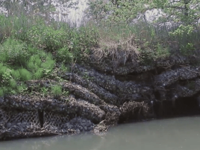
Slumping gabion walls around the ash pits
In the meantime, Dynegy also plans to install gabion walls (cages filled with rocks) to armor a portion of the river bank. The gabions that Dynegy installed years ago are now sitting neglected and in ruin. This has proven to be a minimal impact “band-aid” and cannot provide stability over the long term.
Acknowledging these threats, and the risks to the Middle Fork ecosystem and local economy, Dynegy should move the ash to a location out of the floodplain, out of contact with groundwater, and install modern pollution controls and monitoring.
Timeline
1950′s
- The Vermilion Power Station was built and put into operation by the Illinois Power Company in 1955
- The Old East Ash Pond (OEAP) was part of the original construction of the plant.
1970′s
- The OEAP remained in operation until the mid-1970′s when the North Ash Pond System (NAPS) was brought online
1980′s
- Gabions were installed in 1981 to protect the Old East Ash Pond impoundment
- The NAPS was actively receiving waste from the mid-1970′s to 1989, when the New East Ash Pond System (NEAP) was brought online
2000′s
- Dynegy purchased Illinois Power in 2000, and acquired the Vermilion Power Station as part of the purchase
- Dynegy applied for a bank stabilization permit to install gabions along the east side of the NEAP in 2009, which was not approved
2010′s
- The plant closed on November 19, 2011, and the NEAP became inactive
- All ash ponds are now “out-of-service,” but not fully “closed”
Vermilion County Passes Unanimous Resolutions
In the absence of existing rules to regulate the comprehensive closure of sites like Dynegy Vermilion, Vermilion County groups stepped up to encourage stronger rules at the state level and additional consideration for closure of ash pits at the Dynegy Vermilion facility.
In 2014, a series of resolutions passed unanimously by the Vermilion County Board, Soil & Water Conservation District, Vermilion County Conservation District, Vermilion County Conservation Foundation, and the Lake Vermilion Water Quality Coalition, calling on the Illinois Pollution Control Board to address regulatory shortcomings, and on the Illinois Environmental Protection Agency to address management and public participation issues as they apply to the Dynegy Vermilion closure plan.
What about the U.S. EPA Coal Ash Rules?
On October 19th, the U.S. EPA’s new safeguards on the disposal of coal ash went into effect nationwide. The rules are targeted to prevent impoundment failures (like the massive Kingston, Tennessee spill in 2008), protect groundwater beneath coal ash disposal sites, and establish basic requirements for maintaining these massive waste storage pits.
Unfortunately, legacy impoundments — the old, polluting pits like Dynegy Vermilion, storing tons of coal ash next to our rivers, lakes, and streams — are left largely unregulated. Illinois is home to 91 coal ash pits, many of which are located at now-shuttered power generating facilities.
These pits will need Illinois-specific rules to protect the surrounding communities and water ways. These rules are in motion, but at risk from industry attacks (i.e., power plant operators who could easily leave the damages for communities to pay).